Storm Alert: Flash Flooding Risk and Severe Thunderstorms Lashing the Coast
Friday Weather Outlook: Wet and Wild Conditions Ahead
Sunshine Coast residents are advised to keep their umbrellas close and stay alert to changing conditions today, Friday, 13 February 2026. A significant weather system is moving through the region, bringing heavy rain and the potential for severe thunderstorms that could impact the morning commute and afternoon school runs. With the Bureau of Meteorology indicating a very high chance of precipitation, the region is preparing for a day of unsettled and potentially hazardous weather.
Morning and Afternoon: Thunderstorm and Flash Flood Warning
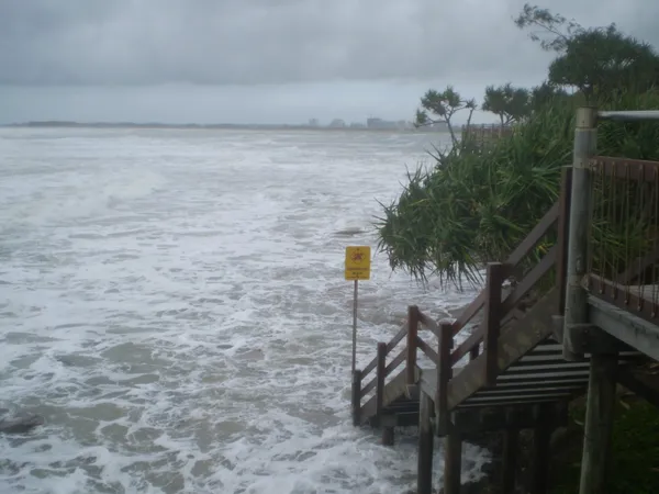
The day is expected to start under heavy overcast skies, with rain becoming increasingly likely as the morning progresses. Meteorological data indicates a very high chance of rain across the entire Sunshine Coast area. Of particular concern is the high probability of thunderstorms developing during both the morning and afternoon periods. These storms may become severe, carrying the threat of intense rainfall bursts that could lead to localized flash flooding in low-lying areas and on coastal roads. Residents in flood-prone zones are urged to monitor local alerts and ensure that gutters and drainage systems are clear of debris.
- Morning: High humidity and a building chance of thunderstorms. Isolated heavy falls are expected to begin before midday, potentially affecting visibility for motorists.
- Afternoon: Storm activity is predicted to peak during the afternoon hours, with the highest risk of severe weather and intense rain totals.
- Evening: Conditions will remain cloudy with lingering rain showers. While the intensity of storm activity is expected to ease after sunset, the region will remain damp into the night.
Temperatures and Coastal Winds
Despite the persistent wet weather, temperatures will remain relatively warm, resulting in a muggy and uncomfortable atmosphere. The mercury is forecast to reach a high of 28°C, while overnight temperatures will hover around a mild 22°C to 23°C. Humidity levels are expected to be exceptionally high, peaking between 88% and 95% throughout the day.
Wind conditions will fluctuate as the weather system moves through. Early light winds are forecast to shift to the east and northeasterly by the middle of the day, reaching speeds of 15 to 25 km/h. As we move into the late evening, the breeze is likely to tend east to southeasterly, easing slightly to between 15 and 20 km/h.
Safety and UV Notices
The UV Index for the Sunshine Coast today is predicted to reach a moderate level of 3. While the thick cloud cover will provide some natural protection, sun safety measures are still recommended during any breaks in the rain. However, the primary safety concern for today remains the potential for flash flooding. Emergency services urge motorists to drive to the conditions, avoid parking under large trees during storm activity, and remember the essential safety message: if it's flooded, forget it.

Lunar New Year Celebrations and Digital Art Take Over the Sunshine Coast Today

Coast Morning Briefing: Storm Watches, Tiny Miracles, and Big Rail Debates
Delays on Steve Irwin Way and Heavy Coastal Traffic for Tuesday Commute