Stormy Sunday Ahead: Thunderstorms and Heavy Showers Set to Soak the Coast
Wet Weather Returns to the Sunshine Coast
Residents and visitors across the Sunshine Coast should prepare for a significant shift in conditions this Sunday, March 22, 2026. Following a period of relatively stable weather, a deepening trough and increased moisture from the north are expected to bring a wet and stormy conclusion to the weekend. While the morning may start with nothing more than a few gray clouds, the outlook for the remainder of the day suggests that outdoor plans should be moved undercover.
Morning: A Cloudy and Damp Start
The day is set to begin with extensive cloud cover across the region, from Caloundra up to Noosa. Early morning commuters and those heading to local markets can expect passing showers and high humidity, hovering around 75 to 90 percent. Visibility may be slightly reduced on the roads during these early bursts of rain. As the morning progresses, the atmosphere will become increasingly unstable, setting the stage for more intense activity later in the day.
Afternoon: Thunderstorm Risk Increases
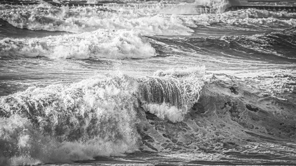
The primary concern for today is the high probability of scattered thunderstorms developing during the afternoon hours. Forecast models indicate a 40 to 60 percent chance of precipitation, with some areas likely to experience heavy falls and lightning. These storms are being driven by a low-pressure system interacting with moist southeasterly winds. If you are planning to be near the water or in open parks, remain vigilant for darkening skies and the sound of thunder, as these systems can develop rapidly across the hinterland before moving toward the coast.
Evening: Tapering to Light Rain
As the sun sets at approximately 5:57 PM, the peak intensity of the storm activity is expected to subside. However, the region will remain under a blanket of thick cloud. The evening prediction points toward persistent light rain and periodic drizzle, keeping the roads slick into the night. Temperatures will remain mild, making for a humid but cool night for sleeping.
Temperature and Wind Outlook
Despite the rain, temperatures will remain within a comfortable autumn range. Expect a daytime maximum of 25°C, with overnight lows dipping to around 19°C. Winds will be primarily from the southeast, averaging 15 km/h, though they may become gusty and unpredictable in the immediate vicinity of any thunderstorm activity.
- Keep an umbrella and waterproof jacket handy throughout the day.
- Ensure gutters and drains are clear to manage potential heavy downpours.
- Exercise caution on the roads, particularly during the afternoon storm window.
- Monitor local alerts if you are in low-lying areas prone to flash flooding.
Sun, Surf Culture, and the Sea of Purple: What’s On Today in Sunshine Coast
Purple Maroochydore and Surfing Legends: The Sunday Briefing

Triathlon Closures: Major Sunshine Motorway and Mooloolaba Road Shutdowns this Sunday