Passing Showers and Fresh Breezes: Saturday Weather Update for the Coast
Passing Showers and Fresh Breezes: Saturday Weather Update for the Coast
Residents and visitors across the Sunshine Coast can expect a mix of cloud cover and intermittent rain this Saturday, February 28, 2026. As we close out the month, the region is set to experience classic subtropical variability, with meteorological data indicating a high likelihood of showers throughout the day and a consistent cloud layer hanging over the coastline.
Morning Forecast: A Grey Start
The day began with a relatively mild start as temperatures hovered around 22°C to 23°C in the early hours. Sunrise at 5:40 AM revealed a mostly cloudy sky across coastal suburbs like Maroochydore and Mooloolaba. For those heading out for early exercise or a morning coffee, the humidity remains quite high, sitting at approximately 90%. While the morning may start dry for many, the first of the passing showers is expected to move inland from the Coral Sea before mid-morning. Keeping a light raincoat handy is advisable for anyone planning outdoor activities before noon.
Afternoon Outlook: Peak Temperatures and Showers
As we head into the afternoon, temperatures are expected to reach a maximum of 26°C to 28°C. While these figures are moderate for late February, the "feels like" temperature may be slightly higher due to the moisture in the air. The chance of rainfall remains elevated at roughly 60% during the peak of the day, with most precipitation occurring in short, sharp bursts rather than prolonged downpours. Total rainfall amounts for the 24-hour period are forecasted between 2mm and 4mm, though localized areas may see slightly higher totals if a heavier shower cell passes directly overhead.
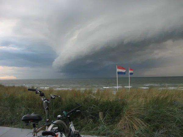
Winds and Marine Conditions
The most significant feature of today's weather is the persistent wind. Strong southeasterlies are blowing at speeds between 25 and 35 km/h along the coastal fringe. These conditions are creating choppy water for boaties, with wave heights offshore reaching up to 1.5 to 2 metres. While there are currently no major storm warnings or cyclone alerts in effect, the fresh breezes will make it feel significantly cooler at the beach. Swimmers should stick to patrolled areas, as the combination of wind and swell can increase the frequency of unpredictable rips.
Evening and Nighttime Conditions
By evening, the temperature will drop back toward a comfortable minimum of 20°C. Sunset at 6:19 PM will likely be obscured by the prevailing cloud cover. Showers are expected to ease slightly after dark, though a 35% to 40% chance of light rain remains through the night. Looking ahead, these damp and breezy conditions are likely to persist into Sunday morning before we see a potentially clearer start to the upcoming work week.
Daily Summary at a Glance
- Maximum Temperature: 28°C
- Minimum Temperature: 20°C
- Wind: Southeasterly at 25–35 km/h
- Rain Probability: 60% chance of showers
- Humidity: High (averaging 80-90%)
St. Paddy’s Day and Surf Culture: What’s On Today in the Sunshine Coast
Green Pints, Smooth Ramps, and Clear Skies: Your Sunshine Coast Tuesday Briefing

Commuter Alert: Major Rail Shutdown and Mooloolaba Traffic Impacts This Tuesday